
Estimación de carbono a nivel árbol individual en bosque natural mediante vehículos aéreos no tripulados (VANT)
DOI:
https://doi.org/10.18387/polibotanica.60.11Palavras-chave:
Teledetección, Contenido de carbono, modelo de altura de dosel, OBIA, VANTResumo
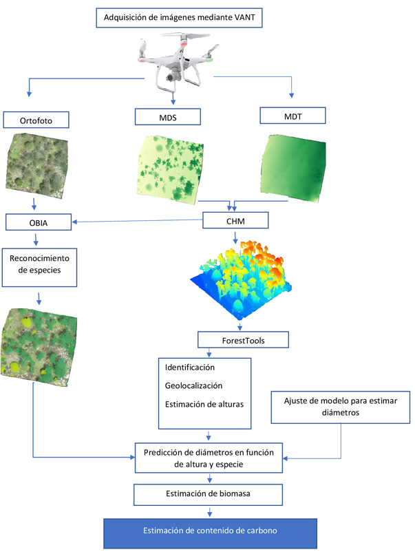
El uso de los vehículos aéreos no tripulados (VANT) ha ido en aumento en los últimos años en el ámbito forestal con aplicaciones como estimación de variables dendrométricas, biomasa aérea y contenido de carbono. Este trabajo tiene como objetivo estimar el contenido de carbono mediante Vehículos Aéreos No Tripulados (VANT) a nivel de árbol individual en bosques templados de la Sierra Madre Occidental en México. A partir de modelos digitales de terreno (MDT) y superficie (MDS) se generó un modelo de altura de dosel (CHM) como base para la estimación de alturas, geolocalización e identificación de árboles usando el paquete ForestTools de RStudio evaluando tres combinaciones de parámetros del algoritmo de filtro de ventana variable (VWF). Además, se realizó un reconocimiento de especies mediante OBIA. Finalmente, se realizó una predicción de biomasa y contenido de carbono usando ecuaciones alométricas. Los resultados mostraron una alta concordancia en la identificación y conteo de árboles (96.10%) con la combinación de 0.05 + 0.6 en los parámetros del algoritmo de VWF. El análisis mostró una correlación de 0.93 y 0.76 y un R2 de 0.87 y 0.58 para alturas y diámetros respectivamente, además un índice Kappa de 0.92 en reconocimiento de especies. Comparando las estimaciones de carbono entre el método tradicional y el uso de VANT, se observó una correlación de 0.74 y un R2 de 0.55, evidenciando una relación moderada entre ambos métodos. Los resultados muestran la viabilidad de los VANT para la estimación de carbono en bosques.
Referências
Barrón, R., Aguirre Calderon, O. A., Larreta, B., Pérez, J., Garza, E., & Yerena Yamallel, J. (2016). Modeling of biomass and aboveground arboreal carbon in forests of the state of Durango. Revista Mexicana de Cienias Forestales, 7, 91–105.
Bhatnagar, S., Gill, L., & Ghosh, B. (2020). Drone Image Segmentation Using Machine and Deep Learning for Mapping Raised Bog Vegetation Communities. Remote Sensing 2020, Vol. 12, Page 2602, 12(16), 2602. https://doi.org/10.3390/RS12162602
Birdal, A. C., Avdan, U., & Türk, T. (2017). Estimating tree heights with images from an unmanned aerial vehicle. Geomatics, Natural Hazards and Risk, 8(2), 1144–1156. https://doi.org/10.1080/19475705.2017.1300608
Bueno-López, S. W., García-Lucas, E., Caraballo-Rojas, L. R., Bueno-López, S. W., García-Lucas, E., & Caraballo-Rojas, L. R. (2019). Allometric equations for total aboveground dry biomass and carbon content of Pinus occidentalis trees. Madera y Bosques, 25(3). https://doi.org/10.21829/MYB.2019.2531868
Chen, S., Liang, D., Ying, B., Zhu, W., Zhou, G., & Wang, Y. (2021). Assessment of an improved individual tree detection method based on local-maximum algorithm from unmanned aerial vehicle RGB imagery in overlapping canopy mountain forests. International Journal of Remote Sensing, 42(1), 106–125. https://doi.org/10.1080/01431161.2020.1809024
Corral-Rivas, J. J., Barrio-Anta, M., Aguirre-Calderón, O. A., & Diéguez-Aranda, U. (2007). Use of stump diameter to estimate diameter at breast height and tree volume for major pine species in El Salto, Durango (Mexico). Forestry: An International Journal of Forest Research, 80(1), 29–40. https://doi.org/10.1093/FORESTRY/CPL048
Corral-Rivas, J. J., Vargas Larreta, B., Wehenkel, C., Aguirre-Calderón, O. A., Álvarez-González, J. G., & Rojo-Alboreca, A. (2009). Guía para el establecimiento de sitios de investigación forestal y de suelos en bosques del estado de Durango. Editorial de La Universidad Juárez Del Estado de Durango., octubre 2017, 54p. https://www.researchgate.net/publication/305640430%0AGuía
Cuevas, X. G., Ramos, J. H., Ramos, A. H., Quiñonez Barraza, G., Carlos, J., Urías, T., Geraldine, G., & Espinoza, G. (2017). Predicción del diámetro normal, altura y volumen a partir del diámetro del tocón en especies tropicales. Revista Mexicana de Ciencias Forestales, 8(43), 089–116. https://doi.org/10.29298/RMCF.V8I43.67
Dainelli, R., Toscano, P., Di Gennaro, S. F., & Matese, A. (2021). Recent Advances in Unmanned Aerial Vehicles Forest Remote Sensing—A Systematic Review. Part II: Research Applications. Forests, 12(4). https://doi.org/10.3390/f12040397
FAO. (2021, October). Marco estratégico para 2022-2031. https://openknowledge.fao.org/items/b9ad3bb8-39c5-447f-8eec-6a333e003cf7
Franklin, S. E. (2018). Pixel-and object-based multispectral classification of forest tree species from small unmanned aerial vehicles. Journal of Unmanned Vehicle Systems, 6(4), 195–211. https://doi.org/10.1139/JUVS-2017-0022
Gallardo-Salazar, J. L., & Pompa-García, M. (2020). Detecting Individual Tree Attributes and Multispectral Indices Using Unmanned Aerial Vehicles: Applications in a Pine Clonal Orchard. Remote Sensing, 12(24). https://doi.org/10.3390/rs12244144
Hao, Z., Lin, L., Post, C. J., Jiang, Y., Li, M., Wei, N., Yu, K., & Liu, J. (2021). Assessing tree height and density of a young forest using a consumer unmanned aerial vehicle (UAV). New Forests, 52(5), 843–862. https://doi.org/10.1007/s11056-020-09827-w
Hernando, A., Puerto, L., Mola-Yudego, B., Manzanera, J., Abril, A., Maltamo, M., & Valbuena, R. (2019). Estimation of forest biomass components using airborne LiDAR and multispectral sensors. IForest - Biogeosciences and Forestry, 12, 207–213. https://doi.org/10.3832/ifor2735-012
Hinojosa-Espinoza, S. I., Gallardo-Salazar, J. L., Hinojosa-Espinoza, F. J. C., & Meléndez-Soto, A. (2021). Evaluation of segmentation parameters in OBIA for classification of land covers from UAV images. Revista de Teledetección, 2021(58), 89–103. https://doi.org/10.4995/RAET.2021.14782
Islami, M. M., Rusolono, T., Setiawan, Y., Rahadian, A., Hudjimartsu, S. A., & Prasetyo, L. B. (2021). Height, diameter and tree canopy cover estimation based on unmanned aerial vehicle (UAV) imagery with various acquisition height . Media Konservasi, 26(1 SE-Research Articles), 17–27. https://doi.org/10.29244/medkon.26.1.17-27
Jayathunga, S., Owari, T., & Tsuyuki, S. (2018). The use of fixed–wing UAV photogrammetry with LiDAR DTM to estimate merchantable volume and carbon stock in living biomass over a mixed conifer–broadleaf forest. International Journal of Applied Earth Observation and Geoinformation, 73, 767–777. https://doi.org/10.1016/J.JAG.2018.08.017
Ke, Y., & Quackenbush, L. J. (2011). A review of methods for automatic individual tree-crown detection and delineation from passive remote sensing. International Journal of Remote Sensing, 32(17), 4725–4747. https://doi.org/10.1080/01431161.2010.494184
Komárek, J., Klouček, T., & Prošek, J. (2018). The potential of Unmanned Aerial Systems: A tool towards precision classification of hard-to-distinguish vegetation types? International Journal of Applied Earth Observation and Geoinformation, 71, 9–19. https://doi.org/https://doi.org/10.1016/j.jag.2018.05.003
Kwong, I. H. Y., & Fung, T. (2020). Tree height mapping and crown delineation using LiDAR, large format aerial photographs, and unmanned aerial vehicle photogrammetry in subtropical urban forest. International Journal of Remote Sensing, 41(14), 5228–5256. https://doi.org/10.1080/01431161.2020.1731002
Li, Z., Zan, Q., Yang, Q., Zhu, D., Chen, Y., & Yu, S. (2019). Remote Estimation of Mangrove Aboveground Carbon Stock at the Species Level Using a Low-Cost Unmanned Aerial Vehicle System. Remote Sensing 2019, Vol. 11, Page 1018, 11(9), 1018. https://doi.org/10.3390/RS11091018
Mohan, M., Silva, C. A., Klauberg, C., Jat, P., Catts, G., Cardil, A., Hudak, A. T., & Dia, M. (2017). Individual Tree Detection from Unmanned Aerial Vehicle (UAV) Derived Canopy Height Model in an Open Canopy Mixed Conifer Forest. Forests, 8(9). https://doi.org/10.3390/f8090340
Morales, E. A. F., Calderón, O. A. A., Barraza, G. Q., Tagle, M. A. G., & Pérez, J. J. (2019). Estimación del diámetro normal, altura y volumen de Pinus pseudostrobus Lindl. en función del diámetro del tocón. Revista Mexicana de Ciencias Forestales, 10(55). https://doi.org/10.29298/RMCF.V10I55.547
Nanos, N., & Sjöstedt de Luna, S. (2017). Fitting diameter distribution models to data from forest inventories with concentric plot design. Forest Systems, 26(2 SE-SPECIAL SECTION MEDITERRANEAN SILVICULTURE: HOMAGE TO GREGORIO MONTERO), e01S. https://doi.org/10.5424/fs/2017262-10486
Nasiri, V., Darvishsefat, A. A., Arefi, H., Pierrot-Deseilligny, M., Namiranian, M., & Le Bris, A. (2021). Unmanned aerial vehicles (UAV)-based canopy height modeling under leaf-on and leaf-off conditions for determining tree height and crown diameter (case study: Hyrcanian mixed forest). Canadian Journal of Forest Research, 51(7), 962–971. https://doi.org/10.1139/cjfr-2020-0125
Nesbit, P. R., & Hugenholtz, C. H. (2019). Enhancing UAV–SfM 3D Model Accuracy in High-Relief Landscapes by Incorporating Oblique Images. Remote Sensing 2019, Vol. 11, Page 239, 11(3), 239. https://doi.org/10.3390/RS11030239
Novo-Fernández, A., Franks, S., Wehenkel, C., López-Serrano, P. M., Molinier, M., & López-Sánchez, C. A. (2018). Landsat time series analysis for temperate forest cover change detection in the Sierra Madre Occidental, Durango, Mexico. International Journal of Applied Earth Observation and Geoinformation, 73, 230–244. https://doi.org/https://doi.org/10.1016/j.jag.2018.06.015
Ortiz, D., Hernandez, F., & Hernandez, F. (2019). Análisis de la influencia de los puntos de control terrestre en la exactitud posicional de ortofotomosaicos generados por medio de un vuelo fotogramétrico realizado por un vehículo aéreo no tripulado (VANT). Revista de Topografía AZIMUT, 10(1 SE-Artículos). https://revistas.udistrital.edu.co/index.php/azimut/article/view/14972
Palacios-Cruz, D., De Los Santos-Posadas, H. M., Ángeles-Pérez, G., Fierros, A., & Santiago-García, W. (2020). Sistema de crecimiento y rendimiento para evaluar sumideros de carbono en bosques de Pinus patula Schiede ex Schltdl. et Cham. bajo aprovechamiento forestal. Agrociencia, 45, 241–257.
Pino V., E. (2019). Los drones una herramienta para una agricultura eficiente: un futuro de alta tecnología. Idesia (Arica), 37, 75–84.
Popescu, S. C., & Wynne, R. H. (2004). Seeing the trees in the forest: Using lidar and multispectral data fusion with local filtering and variable window size for estimating tree height. Photogrammetric Engineering and Remote Sensing, 70(5), 589–604. https://doi.org/10.14358/PERS.70.5.589
Qin, H., Zhou, W., Yao, Y., & Wang, W. (2021). Estimating Aboveground Carbon Stock at the Scale of Individual Trees in Subtropical Forests Using UAV LiDAR and Hyperspectral Data. Remote Sensing, 13(24). https://doi.org/10.3390/rs13244969
Reche, M. A., & Lanzelotti, S. L. (2024). Nuevos datos para la evaluación de precisiones obtenidas en relevamientos topográficos utilizando VANT (Comentarios sobre Reche et al., 2023). Anuario de La División Geografía, 18 SE-Artículos, 1–12. https://anuario-geografia.unlu.edu.ar/anugeografia/article/view/214
Rosenfield, G. H., & Fitzpatrick-Lins, K. (1986). A coefficient of agreement as a measure of thematic classification accuracy. Photogrammetric Engineering and Remote Sensing, 52(2), 223–227.
Sanaa, F., Imane, S., Mohamed, B., Kenza, A. E., Souhail, K., Lfalah, H., & Khadija, M. (2022). Biomass and Carbon Stock Quantification in Cork Oak Forest of Maamora Using a New Approach Based on the Combination of Aerial Laser Scanning Carried by Unmanned Aerial Vehicle and Terrestrial Laser Scanning Data. Forests, 13(8). https://doi.org/10.3390/f13081211
Seifert, E., Seifert, S., Vogt, H., Drew, D., van Aardt, J., Kunneke, A., & Seifert, T. (2019). Influence of Drone Altitude, Image Overlap, and Optical Sensor Resolution on Multi-View Reconstruction of Forest Images. Remote Sensing 2019, Vol. 11, Page 1252, 11(10), 1252. https://doi.org/10.3390/RS11101252
Vargas-Larreta, B., López-Sánchez, C. A., Corral-Rivas, J. J., López-Martínez, J. O., Aguirre-Calderón, C. G., & Álvarez-González, J. G. (2017). Allometric Equations for Estimating Biomass and Carbon Stocks in the Temperate Forests of North-Western Mexico. Forests, 8(8). https://doi.org/10.3390/f8080269
Vashum, K. (2012). Methods to Estimate Above-Ground Biomass and Carbon Stock in Natural Forests - A Review. Journal of Ecosystem & Ecography, 02. https://doi.org/10.4172/2157-7625.1000116
Vega, A. A., Corral-Rivas, S., Corral-Rivas, J. J., & Diéguez-Aranda, U. (2022). Modelación de las estructuras diamétricas en bosques naturales de Pueblo Nuevo, Durango. Revista Mexicana de Ciencias Forestales, 13(73 SE-Artículo Científico), 75–101. https://doi.org/10.29298/rmcf.v13i73.1187
Wu, X., Shen, X., Cao, L., Wang, G., & Cao, F. (2019). Assessment of Individual Tree Detection and Canopy Cover Estimation using Unmanned Aerial Vehicle based Light Detection and Ranging (UAV-LiDAR) Data in Planted Forests. Remote Sensing, 11(8). https://doi.org/10.3390/rs11080908
Yang, K.; Zhang, H.; Wang, F.; Lai, R., Marino, A., Rizzoli, P., Yang, K., Zhang, H., Wang, F., & Lai, R. (2022). Extraction of Broad-Leaved Tree Crown Based on UAV Visible Images and OBIA-RF Model: A Case Study for Chinese Olive Trees. Remote Sensing 2022, Vol. 14, Page 2469, 14(10), 2469. https://doi.org/10.3390/RS14102469
Young, D. J. N., Koontz, M. J., & Weeks, J. (2022a). Optimizing aerial imagery collection and processing parameters for drone-based individual tree mapping in structurally complex conifer forests. Methods in Ecology and Evolution, 13(7), 1447–1463. https://doi.org/https://doi.org/10.1111/2041-210X.13860
Yudha, P., Setiahadi, R., Sadono, R., Lukito, M., Martono, D., & Matatula, J. (2020). Allometric equations for estimating biomass of community forest tree species in Madiun, Indonesia. Biodiversitas Journal of Biological Diversity, 21, 4291–4300. https://doi.org/10.13057/biodiv/d210947
Downloads
Publicado
Licença
Copyright (c) 2025 POLIBOTÁNICA

Este trabalho está licenciado sob uma licença Creative Commons Attribution-NonCommercial-ShareAlike 4.0 International License.

Polibotánica por Departamento de Botánica de la Escuela Nacional de Ciencias Biológicas del Instituto Politécnico Nacional se distribuye bajo una Licencia Creative Commons Atribución-NoComercial-CompartirIgual 4.0 Internacional.