Variation of dnbr and rbr thresholds in forest fire detection in the Iztaccihuatl-Popocatepetl area, Mexico
DOI:
https://doi.org/10.18387/polibotanica.60.3Keywords:
Forest fires, Spectral indices, Kappa coefficient, Threshold, LandsatAbstract
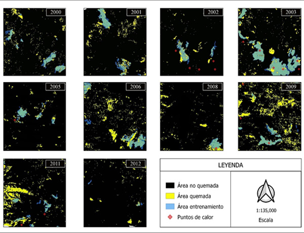
Wildfires are disturbances that influence the composition, structure, and functioning of ecosystems, forming part of ecological cycles whose frequency and severity can vary annually. The use of remote sensors and spectral indices enables the analysis of wildfire dynamics through the Normalized Burn Ratio (NBR), Delta Normalized Burn Ratio (dNBR), and Relative Burn Ratio (RBR). In this context, the aim of the study was to determine and analyze the spatiotemporal variations of dNBR and RBR thresholds to detect areas affected by wildfires in the Iztaccíhuatl-Popocatépetl natural area for the period 2000–2012. Annual Landsat image composites using the 10th percentile were utilized. The RBR and dNBR indices were derived from NBR, allowing the identification of forested areas affected by fires. Concordance (K) was calculated between burned (QUE) and unburned (NOQ) areas. A linear model was fitted for the spectral index with the best metrics. The results showed that RBR thresholds ranged from 50 to 100 (k = 0.71–0.88), while dNBR thresholds ranged from 50 to 130 (k = 0.59–0.83). The linear model explained 80% of the variance, with an RMSE of 7.5 representing the total variance. These results demonstrate the potential of the RBR index for mapping annual burned areas with good accuracy in multitemporal studies. Additionally, the accuracy and variation of the thresholds have changed due to climatic factors such as periods of intense drought and years with higher precipitation.
References
Alcântara, E. F. de, & Fernandes, R. D. O. (2020). Mapeamento e análise dos níveis de severidade de áreas de queimadas no semiárido Brasileiro com o uso técnicas de geoprocessamento. Revista de Geografía, 37(3), 148. https://doi.org/10.51359/2238-6211.2020.245683
Allen, C. D., Breshears, D. D., & McDowell, N. G. (2015). On underestimation of global vulnerability to tree mortality and forest die-off from hotter drought in the Anthropocene. Ecosphere, 6(8). https://doi.org/10.1890/ES15-00203.1
Almeida-Leñero, Jl., Giménez de Azcárate, J., González-Trápaga, T., & Cleef, A. M. (2015). Vegetación alpina de los volcanes Popocatépetl, Iztaccíhuatl y Nevado de Toluca. In I. Luna, J. J. Morrone, & D. Espinosa (Eds.), Biodiversidad de la Faja Volcánica Transmexicana (pp. 179–198). FES- Zaragoza-CONABIO. https://www.researchgate.net/publication/40099917
Amaya, J. A., & Chuvieco, E. (2012). Accuracy Assessment of burned area products in the Orinoco Basin. Photogrammetric Engineering & Remote Sensing, 78, 53–60. https://doi.org/https://doi.org/10.14358/PERS.78.1.53
Anaya, J. A., Sione, W. F., & Rodríguez-Montellano, A. M. (2018). Identificación de áreas quemadas mediante el análisis de series de tiempo en el ámbito de computación en la nube. Revista de Teledetección, 61–73. https://doi.org/https://doi.org/10.4995/raet.2018.8618
Arriola Padilla, V. J., Martínez Estrada, E., Ortega-Rubio, A., Pérez Miranda, R., & Gijón Hernández, A. R. (2014). Deterioro en áreas naturales protegidas del centro de México y del Eje Neovolcánico Transversal. Investigación y Ciencia de La Universidad Autónoma de Aguascalientes, 60, 37–49. http://www.redalyc.org/articulo.oa?id=67431160005
Barmpoutis, P., Papaioannou, P., Dimitropoulos, K., & Grammalidis, N. (2020). A review on early forest fire detection systems using optical remote sensing. Sensors (Switzerland), 20(22), 1–26. https://doi.org/https://doi.org/10.3390/s20226442
Bassaber-Zuñiga, A. I., Maldonado Villegas, M. M., Curiel-Guevara, S., Rojas-Arias, M. L., & Valdez-Rosas, J. S. (2024). Revisión de causas, consecuencias y medidas de respuesta frente a los incendios forestales: un enfoque en el estado de jalisco. E-CUCBA, 11(21), 100–114. https://doi.org/https://doi.org/10.32870/e-cucba.vi21.327
Botella-Martínez, M. A., & Fernández-Manso, A. (2017). Estudio de la severidad post-incendio en la comunidad Valenciana comparando los índices dNBR, RdNBR y RBR a partir de imágenes Landsat 8. Revista de Teledetección, 2017(49), 33–47. https://doi.org/https://doi.org/10.4995/raet.2017.7095
Choat, B., Brodribb, T. J., Brodersen, C. R., Duursma, R. A., López, R., & Medlyn, B. E. (2018). Triggers of tree mortality under drought. Nature, 558(7711), 531–539. https://doi.org/10.1038/s41586-018-0240-x
Chuvieco, E., Mouillot, F., van der Werf, G. R., San Miguel, J., Tanasse, M., Koutsias, N., García, M., Yebra, M., Padilla, M., Gitas, I., Heil, A., Hawbaker, T. J., & Giglio, L. (2019). Historical background and current developments for mapping burned area from satellite Earth observation. Remote Sensing of Environment, 225, 45–64. https://doi.org/https://doi.org/10.1016/j.rse.2019.02.013
Chuvieco, E., Ventura, G., Martín, M. P., & Gómez, I. (2005). Assessment of multitemporal compositing techniques of MODIS and AVHRR images for burned land mapping. Remote Sensing of Environment, 94(4), 450–462. https://doi.org/https://doi.org/10.1016/j.rse.2004.11.006
Cisneros-Vaca, C., Calahorrano, J., Abarca, M., & Manzano, M. (2023). Detección semiautomatica de áreas quemadas en Chimborazo-Ecuador utilizando medias compuestas de dNBR con umbrales ajustados. Revista de Teledetección, 2023(62), 89–99. https://doi.org/https://doi.org/10.4995/raet.2023.19428
Comisión Nacional del Agua - CONAGUA, & Servicio Metereológico Nacional - SMN. (2015). Monitor de Sequía en México. https://smn.conagua.gob.mx/es/climatologia/monitor-de-sequia/monitor-de-sequia-en-mexico
De Luca, G., Silva, J. M. N., & Modica, G. (2022). Regional-scale burned area mapping in Mediterranean regions based on the multitemporal composite integration of Sentinel-1 and Sentinel-2 data. GIScience and Remote Sensing, 59(1), 1678–1705. https://doi.org/10.1080/15481603.2022.2128251
Fernández-García, V., Quintano, C., Taboada, A., Marcos, E., Calvo, L., & Fernández-Manso, A. (2018). Remote sensing applied to the study of fire regime attributes and their influence on Post-Fire greenness recovery in Pine Ecosystems. Remote Sensing, 10(5). https://doi.org/https://doi.org/10.3390/rs10050733
Flores-Rodríguez, A. G., Flores-Garnica, J. G., González-Eguiarte, D. R., Gallegos-Rodríguez, A., Zarazúa-Villaseñor, P., & Mena-Munguía, S. (2021). Análisis comparativo de índices espectrales para ubicar y dimensionar niveles de severidad de incendios forestales. Investigaciones Geográficas UNAM, 106. https://doi.org/https://doi.org/10.14350/rig.60396
Fornacca, D., Ren, G., & Xiao, W. (2018). Evaluating the best spectral indices for the detection of burn scars at several post-fire dates in a Mountainous Region of Northwest Yunnan, China. Remote Sensing, 10(8). https://doi.org/10.3390/rs10081196
Fotakidis, V., Chrysafis, I., Mallinis, G., & Koutsias, N. (2023). Continuous burned area monitoring using bi-temporal spectral index time series analysis. International Journal of Applied Earth Observation and Geoinformation, 125. https://doi.org/10.1016/j.jag.2023.103547
Fundación española para la Ciencia y la Tecnología - FECYT. (2023). Incendios forestales y restauración de zonas quemadas. https://doi.org/www.doi.org/10.57952/w67p-j094
Gajendiran, K., Kandasamy, S., & Narayanan, M. (2024). Influences of wildfire on the forest ecosystem and climate change: A comprehensive study. In Environmental Research (Vol. 240). Academic Press Inc. https://doi.org/10.1016/j.envres.2023.117537
Gale, M. G., Cary, G. J., Yebra, M., Leavesley, A. J., & Van Dijk, A. I. J. M. (2022). Comparison of contrasting optical and LiDAR fire severity remote sensing methods in a heterogeneous forested landscape in south-eastern Australia. International Journal of Remote Sensing, 43(7), 2559–2580. https://doi.org/10.1080/01431161.2022.2064197
Galicia, L., Cuevas Fernández, M. L., González Ramírez, L. M., & Couturier, S. (2014). Detección de cambio ambiental en selvas y bosques de México con percepción remota: un enfoque multiescalar de espacio y tiempo. Interciencia, 39(6), 368–374. https://www.redalyc.org/articulo.oa?id=33931213002
Gallegos Rodríguez, A., Alberto González Cueva, G., Gerardo Cabrera Orozco, R., Marcelli Sánchez, C., & Hernández Álvarez, E. (2014). Efecto de la recurrencia de incendios forestales en la diversidad arbórea. Revista Mexicana de Ciencias Forestales, 5(24). https://www.scielo.org.mx/scielo.php?pid=S2007-11322014000400010&script=sci_arttext
García, M. J. L., & Caselles, V. (1991). Mapping burns and natural reforestation using thematic mapper data. Geocarto International, 6(1), 31–37. https://doi.org/https://doi.org/10.1080/10106049109354290
García Sampayo, J. C. (2019). Teledetección de áreas quemadas asociadas a incendios forestales en la Sierra Nevada México (1998-2017) [Tesis de Licenciatura, Universidad Nacional Autónoma de México]. http://132.248.9.195/ptd2019/abril/0788060/0788060.pdf
Gómez-Sánchez, E., de las Heras, J., Lucas-Borja, M., & Moya, D. (2017). Ajuste de metodologías para evaluar severidad de quemado en zonas semiáridas (SE peninsular): incendio Donceles 2012. Revista de Teledetección, 2017(49), 103–113. https://doi.org/https://doi.org/10.4995/raet.2017.7121
González, M. E., Lara, A., Urrutia, R., & Bosnich, J. (2011). Cambio climático y su impacto potencial en la ocurrencia de incendios forestales en la zona centro-sur de Chile (33°- 42°s). Bosque (Valdivia), 32(3), 215–219. https://doi.org/http://dx.doi.org/10.4067/S0717-92002011000300002
Holsinger, L. M., Parks, S. A., Saperstein, L. B., Loehman, R. A., Whitman, E., Barnes, J., & Parisien, M. A. (2022). Improved fire severity mapping in the North American boreal forest using a hybrid composite method. Remote Sensing in Ecology and Conservation, 8(2), 222–235. https://doi.org/https://doi.org/10.1002/rse2.238
Howe, A. A., Parks, S. A., Harvey, B. J., Saberi, S. J., Lutz, J. A., & Yocom, L. L. (2022). Comparing Sentinel-2 and Landsat 8 for Burn Severity Mapping in Western North America. Remote Sensing, 14(20). https://doi.org/10.3390/rs14205249
Jiménez, A. M., Urrego, L. E., & Toro, L. J. (2016). Evaluación del comportamiento de incendios de la vegetación en el norte de Antioquia (Colombia): Análisis del paisaje. Colombia Forestal, 19(2), 161–180. https://doi.org/10.14483/udistrital.jour.colomb.for.2016.2.a03
Jones, M. W., Abatzoglou, J. T., Veraverbeke, S., Andela, N., Lasslop, G., Forkel, M., Smith, A. J. P., Burton, C., Betts, R. A., van der Werf, G. R., Sitch, S., Canadell, J. G., Santín, C., Kolden, C., Doerr, S. H., & Le Quéré, C. (2022). Global and Regional Trends and Drivers of Fire Under Climate Change. In Reviews of Geophysics (Vol. 60, Issue 3). John Wiley and Sons Inc. https://doi.org/10.1029/2020RG000726
Key, C. H., & Benson, N. C. (2006). Landscape Assessment: Ground measure of severity, the Composite Burn Index, and remote sensing of severity, the Normalized Burn Ratio. In R. E. Lutes, J. F. Keane, C. H. Caratti, Key N.C., S. Benson, Sutherland L.J., & Gangi. (Eds.), FIREMON: Fire Effects Monitoring and Inventory System. USDA Forest Service, Rocky Mountain Research Station. https://doi.org/https://doi.org/10.4996/fireecology.0202034
Konkathi, P., & Shetty, A. (2021). Inter comparison of post-fire burn severity indices of Landsat-8 and Sentinel-2 imagery using Google Earth Engine. Earth Science Informatics, 14, 645–653. https://doi.org/10.1007/s12145-020-00566-2/Published
Kraus, D., Wohlgemuth, T., Castellnou, M., & Conedera, M. (2022). Fire in Forest Ecosystems: Processes and Management Strategies. In T. Wohlgemuth, A. Jentsch, & R. Seidl (Eds.), Disturbance Ecology (Springer, Vol. 32, pp. 143–171). https://doi.org/https://doi.org/10.1007/978-3-030-98756-5_7
López-García, J. (2019). Changes in forest cover in Sierra Nevada, Mexico, 1994–2015. Journal of Maps, 15(2), 418–424. https://doi.org/10.1080/17445647.2019.1603125
Luna-Rosales, B. S., Barba-Alvarez, A., Romero-Tirado, R., Pérez-Toledano, E., Perea-Morales, O., Padrón-Hernández, S., Sierra-Jiménez, H., De la Cruz, R., & Jardón-Sánchez, D. (2007). Diversidad de Orquídeas en el “Parque Nacional Iztaccihuatl-Popocatépetl” (México) y sus áreas de influencia. Lankesteriana International Journal on Orchidology, 7(1–2), 56–59. https://www.redalyc.org/pdf/443/44339813011.pdf
Mallinis, G., Mitsopoulos, I., & Chrysafi, I. (2018). Evaluating and comparing sentinel 2A and landsat-8 operational land imager (OLI) spectral indices for estimating fire severity in a mediterranean pine ecosystem of Greece. GIScience and Remote Sensing, 55(1), 1–18. https://doi.org/10.1080/15481603.2017.1354803
Manzo-Delgado, L. L., & López-García, J. (2020). Análisis espacial y temporal de áreas quemadas en 1998, 2003 y 2015 en la Reserva de la Biosfera Montes Azules, Chiapas, México. Bosque (Valdivia), 41(1), 11–24. https://doi.org/http://dx.doi.org/10.4067/S0717-92002020000100011
Miller, J. D., & Thode, A. E. (2007). Quantifying burn severity in a heterogeneous landscape with a relative version of the delta Normalized Burn Ratio (dNBR). Remote Sensing of Environment, 109(1), 66–80. https://doi.org/10.1016/j.rse.2006.12.006
Neger, C., León-Cruz, J. F., Sarmiento, L. G., & Manzo-Delgado, L. de L. (2022). Dinámica espaciotemporal, causas y efectos de los megaincendios en México. Madera y Bosques, 28(2). https://doi.org/https://doi.org/10.21829/myb.2022.2822453
Nolan, R. H., Collins, L., Leigh, A., Ooi, M. K. J., Curran, T. J., Fairman, T. A., Resco de Dios, V., & Bradstock, R. (2021). Limits to post-fire vegetation recovery under climate change. Plant Cell and Environment, 44(11), 3471–3489. https://doi.org/https://doi.org/10.1111/pce.14176
Nolè, A., Rita, A., Spatola, M. F., & Borghetti, M. (2022). Biogeographic variability in wildfire severity and post-fire vegetation recovery across the European forests via remote sensing-derived spectral metrics. Science of the Total Environment, 823. https://doi.org/10.1016/j.scitotenv.2022.153807
Parks, S. A., Dillon, G. K., & Miller, C. (2014). A new metric for quantifying burn severity: The relativized burn ratio. Remote Sensing, 6(3), 1827–1844. https://doi.org/https://doi.org/10.3390/rs6031827
Parks, S. A., Holsinger, L. M., Voss, M. A., Loehman, R. A., & Robinson, N. P. (2018). Mean composite fire severity metrics computed with Google Earth Engine offer improved accuracy and expanded mapping potential. Remote Sensing, 10(6). https://doi.org/https://doi.org/10.3390/rs10060879
Pérez-Bertozzi, L., Vega-Araya, M., Díaz-Orias, J., & Guadamuz-Eras, D. (2024). Determinación de los efectos ambientales causados por eventos hidrometereológicos extremos que inciden en el manejo del fuego en sitios del Área de Conservación Guanacaste (ACG), Guanacaste, Costa Rica. Revista de Ciencias Ambientales, 58(1), 1–17. https://doi.org/10.15359/rca.58-1.12
Quiroz-Ibarra, A., Torres-Lima, P., & Conway-Gómez, K. (2020). Community adaptive capacity in Peri-urban natural protected areas: A case study near Mexico City. Sustainability (Switzerland), 12(11). https://doi.org/10.3390/su12114416
Smichowski, H., Montiel, M. del R., Romero, V., Kowalewski, M., & Contreras, F. I. (2022). Evaluación de incendios en áreas periurbanas de la ciudad de Corrientes (Argentina) durante el año 2020. Papeles de Geografía, 67, 151–167. https://doi.org/10.6018/geografia.486441
Urzúa, N., & Cáceres, F. (2011). Incendios forestales: principales consecuencias económicas y ambientales en Chile. INTERAMERICAN JOURNAL OF ENVIRONMENT AND TOURISM , 7(1), 18–24. https://doi.org/http://dx.doi.org/10.4067/riatvol7iss1pp18-24%250718-235X
Valdez-Zavala, K. M., Bravo-Peña, L. C., & Manzo-Delgado, L. L. (2019). Áreas quemadas y cambio de uso del suelo en el suroeste de Chihuahua (México) durante el periodo 2013-2017: Identificación con el índice Normalized Burn Ratio (NBR). Acta Universitaria, 29(2007–9621). https://doi.org/https://doi.org/10.15174/au.2019.2418
Van Mantgem, P. J., Falk, D. A., Williams, E. C., Das, A. J., & Stephenson, N. L. (2018). Pre-fire drought and competition mediate post-fire conifer mortality in western U.S. National Parks. Ecological Applications, 28(7), 1730–1739. https://doi.org/https://doi.org/10.1002/eap.1778
Vargas-Sanabria, D., & Campos-Vargas, C. (2020). Comparación multitemporal de áreas quemadas en un bosque seco tropical utilizando el índice de área quemada (IAQ). Revista Forestal Mesoamericana Kurú, 17(41), 29–36. https://doi.org/https://doi.org/10.18845/rfmk.v17i41.5280
Viedma, O., Chico, F., Fernández, J. J., Madrigal, C., Safford, H. D., & Moreno, J. M. (2020). Disentangling the role of prefire vegetation vs. burning conditions on fire severity in a large forest fire in SE Spain. Remote Sensing of Environment, 247. https://doi.org/https://doi.org/10.1016/j.rse.2020.111891
Vlassova, L., Pérez-Cabello, F., Mimbrero, M. R., Llovería, R. M., & García-Martín, A. (2014). Analysis of the relationship between land surface temperature and wildfire severity in a series of landsat images. Remote Sensing, 6(7), 6136–6162. https://doi.org/10.3390/rs6076136
Zuluaga Gómez, O. A., Patiño Quinchía, J. E., & Valencia Hernández, G. M. (2021). Modelos implementados en el análisis de tiempo de temperatura superficial e índices de vegetación: una propuesta taxonómica en el contexto de cambio climático global. Revista de Geografía Norte Grande, 78, 323–344. https://doi.org/http://dx.doi.org/10.4067/S0718-34022021000100323
Downloads
Published
Issue
Section
License
Copyright (c) 2026 POLIBOTANICA

This work is licensed under a Creative Commons Attribution-NonCommercial-ShareAlike 4.0 International License.

Polibotánica by Departamento de Botánica de la Escuela Nacional de Ciencias Biológicas del Instituto Politécnico Nacional se distribuye bajo una Licencia Creative Commons Atribución-NoComercial-CompartirIgual 4.0 Internacional.